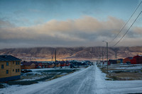
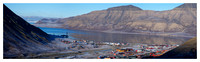
Longyearbyen is the largest settlement and the
administrative center of
Svalbard,
Norway. As of 2008, the town had a population of 2,040. Longyearbyen is located in the valley of
Longyeardalen and on the shore of
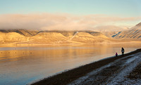
Adventfjorden, a bay of
Isfjorden located on the west coast of
Spitsbergen. Since 2002,
Longyearbyen Community Council has had many of the same responsibilities of a
municipality, including utilities, education, cultural facilities, fire department, roads and ports. The town is the seat of the
Governor of Svalbard. It is the world's
northernmost town, and the northernmost settlement of any kind with greater than 1,000 permanent residents.
Known as
Longyear City until 1926, the town was established by and named after
John Munro Longyear, whose
Arctic Coal Company started
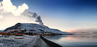
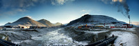
coal miningoperations in 1906. Operations were taken over by
Store Norske Spitsbergen Kulkompani (SNSK) in 1916, which still conducts mining. The town was almost completely destroyed by the German
Kriegsmarine on 8 August 1943, but was rebuilt after the
Second World War.
Interactive map of Svalbard from the Norwegian Polar Institute
Participants included:Claire Liberman,
Karen Power,
Laura Petrovich-Cheney,
Tom Snelgrove,
Kate Puccia,
Ari Belathar,
Han Sungpil,
Lauren Portada,
Allison Cameron,
Jolene Mok,
Joyce Majiski,
Elaine Spatz-Rabinowitz,
Diane Burko, Richard Ryan,
Lisa Goren,
Jane Isakson,
Deborah Hamon,
Hanna Campbell, Gisela Gari,
Kinez Riza,
Marlene Nicols,
Kaisu Koivisto,
Marianna Williams, Tina Kohlmann, Terry Adkins,
Vincent Huang

![[Group 1]-_EDM8083 - Version 2__EDM8087 - Version 2-5 images](/img/s/v-10/p1033407431-11.jpg)